 Tracking points through history
by Eric Do Throughout this project I aimed to create a function that could return which countries a point was a part of throughout a certain point in time. Branching off of this function, I created visualizations displaying how country borders interacted with points throughout history. I also created a heat-map representing which points were the most contested throughout history. There is a lot of data on how countries' borders have transformed throughout history, but not on specific points in relation to those transformations. I thought that it would be interesting to see how points have interacted with countries throughout history. From there, I wanted to figure out which points have been fought over most throughout history. Retrieving Historical Country Dates In order to find the countries a point was a part of throughout a period of time, I need to figure out which countries existed in which years. Because constantly accessing entities would slow down my code, I created an association of the format
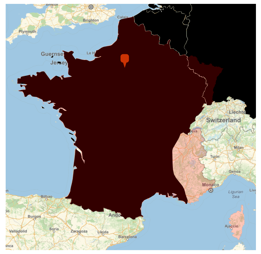
<|country -> {start year, end year}|> so I could easily figure out when countries existed. I n [ ] : = h i s t o r i c a l c o u n t r i e s d a t e s = I f [ ! M i s s i n g Q [ # [ " S t a r t D a t e " ] ] & & ! M i s s i n g Q [ # [ " E n d D a t e " ] ] , I f [ L i s t Q [ # [ " S t a r t D a t e " ] ] | | L i s t Q [ # [ " E n d D a t e " ] ] , { # [ " N a m e " ] , D e l e t e M i s s i n g [ T a b l e [ I f [ ! M i s s i n g Q [ i [ [ 1 ] ] ] & & ! M i s s i n g Q [ i [ [ 2 ] ] ] , { i [ [ 1 , 1 , 1 ] ] , i [ [ 2 , 1 , 1 ] ] } , M i s s i n g [ ] ] , { i , T r a n s p o s e [ { # [ " S t a r t D a t e " ] , # [ " E n d D a t e " ] } ] } ] ] } , { # [ " N a m e " ] , { # [ " S t a r t D a t e " ] [ [ 1 , 1 ] ] , # [ " E n d D a t e " ] [ [ 1 , 1 ] ] } } ] , M i s s i n g [ ] ] & / @ E n t i t y L i s t [ " H i s t o r i c a l C o u n t r y " ] ; h i s t o r i c a l c o u n t r i e s d a t e s = A s s o c i a t i o n T h r e a d [ T r a n s p o s e [ D e l e t e M i s s i n g [ h i s t o r i c a l c o u n t r i e s d a t e s ] ] [ [ 1 ] ] - > T r a n s p o s e [ D e l e t e M i s s i n g [ h i s t o r i c a l c o u n t r i e s d a t e s ] ] [ [ 2 ] ] ] ; c u r r e n t c o u n t r i e s d a t e s = { # [ " N a m e " ] , { # [ " I n d e p e n d e n c e Y e a r " ] [ [ 1 , 1 ] ] , 2 0 2 1 } } & / @ E n t i t y L i s t [ E n t i t y C l a s s [ " C o u n t r y " , " U n i t e d N a t i o n s " ] ] ; c u r r e n t c o u n t r i e s d a t e s = A s s o c i a t i o n T h r e a d [ T r a n s p o s e [ c u r r e n t c o u n t r i e s d a t e s ] [ [ 1 ] ] - > T r a n s p o s e [ c u r r e n t c o u n t r i e s d a t e s ] [ [ 2 ] ] ] ; c o u n t r y d a t e s = U n i o n [ h i s t o r i c a l c o u n t r i e s d a t e s , c u r r e n t c o u n t r i e s d a t e s ] I n [ ] : = c o u n t r y d a t e s = A s s o c i a t i o n I c o n | | | H e a d : A s s o c i a t i o n | | | B y t e c o u n t : 4 1 8 8 2 4 | | ; The following function uses the association above and returns all the countries existing in a certain year. I n [ ] : = E x i s t i n g C o u n t r i e s [ y e a r _ I n t e g e r ] : = D e l e t e D u p l i c a t e s [ D e l e t e M i s s i n g [ F l a t t e n [ T a b l e [ I f [ i [ [ 1 ] ] < = y e a r < = i [ [ 2 ] ] , P o s i t i o n I n d e x [ c o u n t r y d a t e s ] [ i ] , M i s s i n g [ ] ] , { i , V a l u e s [ c o u n t r y d a t e s ] } ] ] ] ] Tracking a Point Through Time First I wanted to figure out which countries a point was a part of throughout a certain period in time. To do this, I planned to use polygons, which are useful for representing 2d spaces, for example, a country's boundaries. The following function retrieves a country's polygon from its name. c o u n t r y n a m e t o p o l y g o n [ c o u n t r y n a m e s _ L i s t , y e a r _ I n t e g e r ] : = D e l e t e C a s e s [ A s s o c i a t i o n T h r e a d [ c o u n t r y n a m e s - > I f [ y e a r = = 2 0 2 1 , E n t i t y V a l u e [ E n t i t y [ " C o u n t r y " , # ] & / @ S t r i n g D e l e t e [ C a p i t a l i z e [ c o u n t r y n a m e s , " A l l W o r d s " ] , " " ] , " P o l y g o n " ] , E n t i t y V a l u e [ E n t i t y [ " H i s t o r i c a l C o u n t r y " , # ] & / @ S t r i n g D e l e t e [ C a p i t a l i z e [ c o u n t r y n a m e s , " A l l W o r d s " ] , " " ] , D a t e d [ " P o l y g o n " , y e a r ] ] ] ] , M i s s i n g [ _ _ _ ] ] Then I made a function that could tell which country a point was a part of in a particular year, given the polygons of each country in that year. w h i c h c o u n t r y [ p o i n t _ G e o P o s i t i o n , c o u n t r i e s a n d p o l y g o n s _ A s s o c i a t i o n ] : = M o d u l e [ { c o u n t r y p o i n t i s i n } , c o u n t r y p o i n t i s i n = D e l e t e M i s s i n g [ I f [ G e o W i t h i n Q [ c o u n t r i e s a n d p o l y g o n s [ # ] , p o i n t ] , # , M i s s i n g [ ] ] & / @ K e y s [ c o u n t r i e s a n d p o l y g o n s ] ] ; I f [ L e n g t h [ c o u n t r y p o i n t i s i n ] = = 0 , R e t u r n [ " N / A " ] , R e t u r n [ c o u n t r y p o i n t i s i n [ [ 1 ] ] ] ] ] This function helps format the years for the execution of the following function. c o n d e n s e d y e a r s [ y e a r s _ L i s t ] : = M o d u l e [ { y e a r s c o n d e n s e d } , ( * c o n v e r t a l i s t l i k e { 1 9 3 2 , 1 9 3 3 , 1 9 3 4 , 1 9 3 5 , 1 9 3 6 , 1 9 4 8 , 1 9 4 9 , 1 9 7 0 } t o { 1 9 3 2 - 1 9 3 6 , 1 9 4 8 - 1 9 4 9 , 1 9 7 0 } * ) y e a r s c o n d e n s e d = F l a t t e n [ { F l a t t e n [ T a b l e [ I f [ y e a r s [ [ i + 1 ] ] - y e a r s [ [ i ] ] = = 1 , y e a r s [ [ i ] ] , { y e a r s [ [ i ] ] , M i s s i n g [ ] } ] , { i , L e n g t h [ y e a r s ] - 1 } ] ] , { y e a r s [ [ - 1 ] ] } } ] ; y e a r s c o n d e n s e d = D e l e t e C a s e s [ S p l i t B y [ y e a r s c o n d e n s e d , M i s s i n g Q ] , { M i s s i n g [ ] } ] ; y e a r s c o n d e n s e d = I f [ L e n g t h [ # ] > 1 , { # [ [ 1 ] ] , # [ [ - 1 ] ] } , # ] & / @ y e a r s c o n d e n s e d ; R e t u r n [ y e a r s c o n d e n s e d ] ] The following function uses all of the ones created above and finds all the countries a point was a part of throughout a given period of time. p o i n t c o u n t r i e s [ l o c a t i o n _ G e o P o s i t i o n , p e r i o d o f t i m e _ L i s t ] : = M o d u l e [ { c o u n t r i e s , t i m e s c o u n t r y o c c u p i e d , k e y s t o d r o p } , c o u n t r i e s = w h i c h c o u n t r y [ l o c a t i o n , c o u n t r y n a m e t o p o l y g o n [ E x i s t i n g C o u n t r i e s [ # ] , # ] ] & / @ R a n g e [ p e r i o d o f t i m e [ [ 1 ] ] , p e r i o d o f t i m e [ [ 2 ] ] ] ; c o u n t r i e s = M e r g e [ T a b l e [ < | c o u n t r i e s [ [ i ] ] - > i + p e r i o d o f t i m e [ [ 1 ] ] - 1 | > , { i , L e n g t h [ c o u n t r i e s ] } ] , I d e n t i t y ] ; c o u n t r i e s = A s s o c i a t i o n T h r e a d [ K e y s [ c o u n t r i e s ] - > ( c o n d e n s e d y e a r s [ c o u n t r i e s [ # ] ] & / @ K e y s [ c o u n t r i e s ] ) ] ; R e t u r n [ c o u n t r i e s ] ] For example, we can use the following piece of code to figure out which countries had control of 49 latitude 2 longitude throughout the early 1900s. I n [ ] : = e x a m p l e p o i n t c o u n t r i e s = p o i n t c o u n t r i e s [ G e o P o s i t i o n [ { 4 9 , 2 } ] , { 1 9 0 0 , 1 9 5 0 } ] ; I n [ ] : = e x a m p l e p o i n t c o u n t r i e s O u t [ ] = F r e n c h T h i r d R e p u b l i c { { 1 9 0 0 , 1 9 4 0 } } , N a z i G e r m a n y { { 1 9 4 1 , 1 9 4 4 } } , P r o v i s i o n a l G o v e r n m e n t O f T h e F r e n c h R e p u b l i c { { 1 9 4 5 } } , F r e n c h F o u r t h R e p u b l i c { { 1 9 4 6 , 1 9 5 0 } } This function allows you to instead of inputting a point with latitude and longitude, to input a current city and find which countries it has been a part of. c i t y c o u n t r i e s [ c i t y _ E n t i t y , p e r i o d o f t i m e _ L i s t ] : = p o i n t c o u n t r i e s [ G e o P o s i t i o n [ c i t y [ " C o o r d i n a t e s " ] ] , p e r i o d o f t i m e ] We can do the same as above but for an actual city, the code below returns the countries Berlin was a part of from 1850 to 1950. I n [ ] : = b e r l i n s c o u n t r i e s = c i t y c o u n t r i e s , { 1 8 5 0 , 1 9 5 0 } ; I n [ ] : = b e r l i n s c o u n t r i e s O u t [ ] = N / A { { 1 8 5 0 , 1 8 6 6 } , { 1 9 4 6 , 1 9 4 9 } } , N o r t h G e r m a n C o n f e d e r a t i o n { { 1 8 6 7 , 1 8 7 0 } } , G e r m a n E m p i r e { { 1 8 7 1 , 1 9 1 7 } } , W e i m a r R e p u b l i c { { 1 9 1 8 , 1 9 3 2 } } , N a z i G e r m a n y { { 1 9 3 3 , 1 9 4 5 } } , E a s t G e r m a n y { { 1 9 5 0 } } As the output of the function above isn't as visually appealing as it could be, I created a function to format that output I n [ ] : = f o r m a t p o i n t c o u n t r i e s [ c o u n t r i e s a n d d a t e s _ A s s o c i a t i o n ] : = S t r i n g D r o p [ S t r i n g J o i n [ T a b l e [ S t r i n g J o i n [ J o i n [ { " , " , i , " : " } , I f [ L e n g t h [ # ] > 1 , S t r i n g J o i n [ { " " , T o S t r i n g [ # [ [ 1 ] ] ] , " - " , T o S t r i n g [ # [ [ 2 ] ] ] } ] , S t r i n g J o i n [ " " , T o S t r i n g [ # [ [ 1 ] ] ] ] ] & / @ c o u n t r i e s a n d d a t e s [ [ i ] ] ] ] , { i , K e y s [ c o u n t r i e s a n d d a t e s ] } ] ] , 1 ; ; 2 ] f o r m a t p o i n t c o u n t r i e s [ b e r l i n s c o u n t r i e s ] Throughout history, there are many times where a country has changed its name without changing its borders (e.g. the French Revolution and the French First Republic becoming the First French Empire under Napoleon ). Because of this, needs to be a way to figure out when a country isn't changing its borders, just its names. The following functions check whether two countries who end and start on the same year or one year apart, have the same polygon, meaning, the name of the country was changed. s a m e c o u n t r y d i f f n a m e [ c o u n t r y 1 _ S t r i n g , c o u n t r y 2 _ S t r i n g , y e a r _ I n t e g e r ] : = I f [ ! M a t c h Q [ E n t i t y [ " H i s t o r i c a l C o u n t r y " , S t r i n g D e l e t e [ C a p i t a l i z e [ c o u n t r y 1 , " A l l W o r d s " ] , " " ] ] [ D a t e d [ " P o l y g o n " , y e a r ] ] , M i s s i n g [ _ _ _ ] ] & & ( ! M a t c h Q [ E n t i t y [ " H i s t o r i c a l C o u n t r y " , S t r i n g D e l e t e [ C a p i t a l i z e [ c o u n t r y 2 , " A l l W o r d s " ] , " " ] ] [ D a t e d [ " P o l y g o n " , y e a r ] ] , M i s s i n g [ _ _ _ ] ] | | ! M a t c h Q [ E n t i t y [ " H i s t o r i c a l C o u n t r y " , S t r i n g D e l e t e [ C a p i t a l i z e [ c o u n t r y 2 , " A l l W o r d s " ] , " " ] ] [ D a t e d [ " P o l y g o n " , y e a r + 1 ] ] , M i s s i n g [ _ _ _ ] ] ) , S a m e Q [ E n t i t y [ " H i s t o r i c a l C o u n t r y " , S t r i n g D e l e t e [ C a p i t a l i z e [ c o u n t r y 1 , " A l l W o r d s " ] , " " ] ] [ D a t e d [ " P o l y g o n " , y e a r ] ] , I f [ y e a r = = 2 0 2 1 , E n t i t y [ " C o u n t r y " , S t r i n g D e l e t e [ C a p i t a l i z e [ c o u n t r y 2 , " A l l W o r d s " ] , " " ] ] [ " P o l y g o n " ] , E n t i t y [ " H i s t o r i c a l C o u n t r y " , S t r i n g D e l e t e [ C a p i t a l i z e [ c o u n t r y 2 , " A l l W o r d s " ] , " " ] ] [ D a t e d [ " P o l y g o n " , y e a r + 1 ] ] ] ] | | S a m e Q [ E n t i t y [ " H i s t o r i c a l C o u n t r y " , S t r i n g D e l e t e [ C a p i t a l i z e [ c o u n t r y 1 , " A l l W o r d s " ] , " " ] ] [ D a t e d [ " P o l y g o n " , y e a r ] ] , I f [ y e a r = = 2 0 2 1 , E n t i t y [ " C o u n t r y " , S t r i n g D e l e t e [ C a p i t a l i z e [ c o u n t r y 2 , " A l l W o r d s " ] , " " ] ] [ " P o l y g o n " ] , E n t i t y [ " H i s t o r i c a l C o u n t r y " , S t r i n g D e l e t e [ C a p i t a l i z e [ c o u n t r y 2 , " A l l W o r d s " ] , " " ] ] [ D a t e d [ " P o l y g o n " , y e a r ] ] ] ] , F a l s e ] ; c o u n t r y c o n t i n u i t y [ c o u n t r y d a t e s _ ] : = M e r g e [ D e l e t e M i s s i n g [ T a b l e [ P r i n t [ i ] ; D e l e t e M i s s i n g [ T a b l e [ I f [ c o u n t r y d a t e s [ i ] [ [ - 1 ] ] = = c o u n t r y d a t e s [ j ] [ [ 1 ] ] | | c o u n t r y d a t e s [ i ] [ [ - 1 ] ] = = c o u n t r y d a t e s [ j ] [ [ 1 ] ] , I f [ s a m e c o u n t r y d i f f n a m e [ i , j , c o u n t r y d a t e s [ i ] [ [ - 1 ] ] ] , < | i - > j | > , M i s s i n g [ ] ] , M i s s i n g [ ] ] , { j , K e y s [ c o u n t r y d a t e s ] } ] ] , { i , K e y s [ c o u n t r y d a t e s ] } ] ] , I d e n t i t y ] The variable below holds an association between countries that are the same, but just changed their names. d i f f n a m e c o u n t r i e s = c o u n t r y c o n t i n u i t y [ c o u n t r y d a t e s ] I n [ ] : = d i f f n a m e c o u n t r i e s = A s s o c i a t i o n I c o n | | | H e a d : A s s o c i a t i o n | | | B y t e c o u n t : 1 6 0 0 | | O u t [ ] = E a s t F r a n c i a H o l y R o m a n E m p i r e , F r e n c h F i r s t R e p u b l i c F i r s t F r e n c h E m p i r e , F r e n c h S e c o n d R e p u b l i c S e c o n d F r e n c h E m p i r e , H e l v e t i c R e p u b l i c S w i s s C o n f e d e r a t i o n M e d i a t i o n , N e w H e b r i d e s V a n u a t u , P o r t u g u e s e F i r s t R e p u b l i c D i t a d u r a N a c i o n a l P o r t u g a l , S a f a v i d E m p i r e A f s h a r i d E m p i r e , S e c o n d F r e n c h E m p i r e F r e n c h T h i r d R e p u b l i c This function uses the association above to figure out the actual number of countries a point was a part of. n u m c o u n t r i e s [ c o u n t r y a s s o c i a t i o n _ A s s o c i a t i o n , d i f f n a m e c o u n t r i e s _ A s s o c i a t i o n ] : = M o d u l e [ { c o u n t r i e s } , c o u n t r i e s = D e l e t e D u p l i c a t e s [ I f [ M e m b e r Q [ K e y s [ d i f f n a m e c o u n t r i e s ] , # ] , d i f f n a m e c o u n t r i e s [ # ] , # ] & / @ K e y s [ c o u n t r y a s s o c i a t i o n ] ] ; R e t u r n [ L e n g t h [ D e l e t e D u p l i c a t e s [ I f [ M e m b e r Q [ K e y s [ d i f f n a m e c o u n t r i e s ] , # ] , d i f f n a m e c o u n t r i e s [ # ] , # ] & / @ K e y s [ c o u n t r y a s s o c i a t i o n ] ] ] ] ] Visualizing the Transformation of Borders Surrounding a Point I thought that the best way to visualize the interaction between a point and the countries around it was through an interactive map. This function will get all the years necessary for the interactive map. I n [ ] : = g e t y e a r s [ c o u n t r y _ ] : = M o d u l e [ { d a t e r a n g e } , I f [ D a t e O b j e c t Q [ D a t e O b j e c t [ c o u n t r y [ " E n d D a t e " ] , " Y e a r " ] ] , d a t e r a n g e = D a t e R a n g e [ D a t e O b j e c t [ c o u n t r y [ " S t a r t D a t e " ] , " Y e a r " ] , D a t e O b j e c t [ c o u n t r y [ " E n d D a t e " ] , " Y e a r " ] ] , d a t e r a n g e = D a t e R a n g e [ D a t e O b j e c t [ c o u n t r y [ " S t a r t D a t e " ] , " Y e a r " ] , D a t e O b j e c t [ N o w , " Y e a r " ] ] ] ; R e t u r n [ d a t e r a n g e ] ] For example, Austria-Hungary existed in the following years: I n [ ] : = g e t y e a r s A u s t r i a - H u n g a r y | H I S T O R I C A L C O U N T R Y | O u t [ ] = , , , , , , , , , , , , , , , , , , , , , , , , , , , , , , , , , , , , , , , , , , , , , , , , , , , This function helps format some previous outputs so that they are compatible for these visualizations. I n [ ] : = g e t r a n g e s [ y e a r s _ L i s t ] : = F l a t t e n [ I f [ L e n g t h [ # ] > 1 , R a n g e [ # [ [ 1 ] ] , # [ [ 2 ] ] ] , # [ [ 1 ] ] ] & / @ y e a r s ] The following function creates the maps necessary for the visualization in a later function. I n [ ] : = g e o l i s t [ c u r r e n t c o u n t r y _ , c o u n t r y _ , l i s t f r o m g e t y e a r s _ , p o i n t _ G e o P o s i t i o n ] : = S e l e c t [ A s s o c i a t i o n T h r e a d [ l i s t f r o m g e t y e a r s , T a b l e [ G e o G r a p h i c s [ { G e o S t y l i n g [ N o n e ] , c o u n t r y [ D a t e d [ " P o l y g o n " , y e a r ] ] , G e o S t y l i n g [ A u t o m a t i c ] , R e d , c u r r e n t c o u n t r y [ " P o l y g o n " ] , G e o M a r k e r [ p o i n t ] } , G e o R a n g e - > c u r r e n t c o u n t r y ] , { y e a r , l i s t f r o m g e t y e a r s } ] ] , F r e e Q [ # , M i s s i n g [ " N o t A p p l i c a b l e " ] ] & ] The following function uses all the functions above to create maps of a point and the current country its in overlaid on the country it was in during a certain year I n [ ] : = v i s u a l i z e p o i n t [ p o i n t _ G e o P o s i t i o n , p o i n t c o u n t r i e s _ A s s o c i a t i o n ] : = M o d u l e [ { c u r r e n t c o u n t r y , c o u n t r y y e a r s , i m a g e s } , c u r r e n t c o u n t r y = w h i c h c o u n t r y [ p o i n t , c o u n t r y n a m e t o p o l y g o n [ E x i s t i n g C o u n t r i e s [ 2 0 2 1 ] , 2 0 2 1 ] ] ; c o u n t r y y e a r s = g e t y e a r s [ E n t i t y [ " H i s t o r i c a l C o u n t r y " , S t r i n g D e l e t e [ C a p i t a l i z e [ # , " A l l W o r d s " ] , " " ] ] ] & / @ D e l e t e C a s e s [ K e y s [ p o i n t c o u n t r i e s ] , " N / A " ] ; c o u n t r y y e a r s = A s s o c i a t i o n T h r e a d [ D e l e t e C a s e s [ K e y s [ p o i n t c o u n t r i e s ] , " N / A " ] - > c o u n t r y y e a r s ] ; c o u n t r y y e a r s = T a b l e [ D e l e t e M i s s i n g [ T a b l e [ I f [ M e m b e r Q [ g e t r a n g e s [ p o i n t c o u n t r i e s [ i ] ] , j [ [ 1 , 1 ] ] ] , j , M i s s i n g [ ] ] , { j , c o u n t r y y e a r s [ i ] } ] ] , { i , K e y s [ c o u n t r y y e a r s ] } ] ; c o u n t r y y e a r s = A s s o c i a t i o n T h r e a d [ D e l e t e C a s e s [ K e y s [ p o i n t c o u n t r i e s ] , " N / A " ] - > c o u n t r y y e a r s ] ; i m a g e s = M e r g e [ D e l e t e C a s e s [ g e o l i s t [ E n t i t y [ " C o u n t r y " , S t r i n g D e l e t e [ C a p i t a l i z e [ c u r r e n t c o u n t r y , " A l l W o r d s " ] , " " ] ] , E n t i t y [ " H i s t o r i c a l C o u n t r y " , S t r i n g D e l e t e [ C a p i t a l i z e [ # , " A l l W o r d s " ] , " " ] ] , c o u n t r y y e a r s [ # ] , p o i n t ] & / @ K e y s [ c o u n t r y y e a r s ] , < | | > ] , I d e n t i t y ] ; R e t u r n [ i m a g e s ] ] Then we use the output of the function above to create a visualization of how the borders surrounding a point have transformed over the years. I n [ ] : = p o i n t v i s u a l i z a t i o n [ i m a g e s _ ] : = M a n i p u l a t e [ i m a g e s [ Y e a r ] [ [ 1 ] ] , { Y e a r , K e y s [ i m a g e s ] } , C o n t r o l T y p e S l i d e r ] In the visualization below, the area covered in black is the country that occupied the given point during that year (which can be changed by moving the slider on top), and the transparent red area is its current country. I n [ ] : = p o i n t v i s u a l i z a t i o n v i s u a l i z e p o i n t G e o P o s i t i o n [ " C o o r d i n a t e s " ] , b e r l i n s c o u n t r i e s Visualizing the most contested areas throughout history I thought that the best way to do this, was to calculate the differences in polygons of the same country between years, and the differences between them would be land that had change hands. To represent this, I planned to plot these polygons transparently, making it so that when land had changed hands multiple times, the transparent polygons would stack on top of each other making the more contested areas darker. In order to figure out the differences between polygons, I needed to reformat their polygons. I n [ ] : = c o r r e c t p r o j e c t i o n [ c o u n t r y _ ] : = ( * c o n v e r t s t h e c o u n t r y i n t o t h e E q u i r e c t a n g u l a r p r o j e c t i o n ( l a t a n d l o n g l i n e u p ) * ) I f [ M i s s i n g Q [ c o u n t r y ] , M i s s i n g [ ] , c o u n t r y / . g p _ G e o P o s i t i o n : > G e o G r i d P o s i t i o n [ g p , " E q u i r e c t a n g u l a r " ] [ [ 1 ] ] ] Next, I created a function to calculate all the land that had been lost or gained by countries in a span of 1 year. I n [ ] : = a r e a c h a n g e d [ s t a r t y e a r _ I n t e g e r , e n d y e a r _ I n t e g e r ] : = M o d u l e [ { s t a r t y e a r c o u n t r i e s , e n d y e a r c o u n t r i e s , c o u n t r y c h a n g i n g p o l y g o n s } , s t a r t y e a r c o u n t r i e s = E x i s t i n g C o u n t r i e s [ s t a r t y e a r ] ; e n d y e a r c o u n t r i e s = E x i s t i n g C o u n t r i e s [ e n d y e a r ] ; c o u n t r y c h a n g i n g p o l y g o n s = I f [ M e m b e r Q [ e n d y e a r c o u n t r i e s , # ] & & L e n g t h [ c o u n t r y n a m e t o p o l y g o n [ { # } , s t a r t y e a r ] ] ! = 0 & & L e n g t h [ c o u n t r y n a m e t o p o l y g o n [ { # } , e n d y e a r ] ] ! = 0 , I f [ ! S a m e Q [ T o S t r i n g [ H e a d [ c o u n t r y n a m e t o p o l y g o n [ { # } , s t a r t y e a r ] [ # ] ] ] , " F i l l e d C u r v e " ] & & ! S a m e Q [ T o S t r i n g [ H e a d [ c o u n t r y n a m e t o p o l y g o n [ { # } , e n d y e a r ] [ # ] ] ] , " F i l l e d C u r v e " ] , { # , R e g i o n S y m m e t r i c D i f f e r e n c e [ c o r r e c t p r o j e c t i o n [ c o u n t r y n a m e t o p o l y g o n [ { # } , s t a r t y e a r ] [ # ] ] , c o r r e c t p r o j e c t i o n [ c o u n t r y n a m e t o p o l y g o n [ { # } , e n d y e a r ] [ # ] ] ] } , M i s s i n g [ ] ] , M i s s i n g [ ] ] & / @ s t a r t y e a r c o u n t r i e s ; R e t u r n [ D e l e t e C a s e s [ D e l e t e M i s s i n g [ c o u n t r y c h a n g i n g p o l y g o n s ] , { _ _ _ , E m p t y R e g i o n [ _ ] } ] ] ( * R E T U R N S A L I S T O F P O L Y G O N S R E P R E S E N T I N G T H E L A N D T H A T C H A N G E D C O U N T R I E S * ) ] The following plot displays land that changed countries more frequently darker. m i d t w e n t y t h c e n t u r y a r e a = F l a t t e n [ T a b l e [ a r e a c h a n g e d [ i , i + 1 ] , { i , R a n g e [ 1 9 2 1 , 1 9 3 9 ] } ] ] I n [ ] : = G e o G r a p h i c s [ { O p a c i t y [ 0 . 1 ] , R e d , T r a n s p o s e [ m i d t w e n t y t h c e n t u r y a r e a ] [ [ 2 ] ] } , G e o P r o j e c t i o n " E q u i r e c t a n g u l a r " , G e o B a c k g r o u n d - > " S t r e e t M a p N o L a b e l s " ] Through this project, I was able to create a function that took a point, and gives back the countries it was in and what year it was in each of them throughout a certain period of time. The main improvement I can make on this project is to try to make these functions faster. Iterating through a bunch of polygons to figure out which country a point is in is inefficient, and I need to find a way to lessen the number of polygons the function needs to iterate through without slowing down the function. I think that it would be really interesting to try to create an algorithm that takes in a point, and based on the time period and where the point is, predict how many countries it has been a part of.  Attachments: Attachments: |
 Message Boards
0 Response to "Mathematica Find Out History of a Tracked Symbol"
Post a Comment